Airborne exploration
Aerospace exploration company «KINPRO-Geophysics»
Our service company, «KINPRO-Geophysics», is a specialized works in sphere of search exploration for hydrocarbons.
We use our own methods and technological solutions (know-how) as at carrying out of geological and geophysical prospecting (exploration) and integrated (complex) processing of all geological and geophysical data obtained in the course of a «remote exploration».
That is, when conducting aerospace geophysical surveys and studies of the continental plot of the continent or its shelf, and integrated processing seismic 2D/3D with the materials of airborne geophysical surveys and construction of 3-dimensional model of localized structures (traps, tanks) containing natural gas (oil).
As a result of the use of our technological know-how, original mathematical and computer environments and programs, conducting costly 2D seismic becomes impractical due to technological reasons. Therefore, the next step after aerospace research is to conduct a 3D seismic survey in the standard HD3D, as well as exploration and appraisal drilling. In this respect, we believe, as have serious practical experience of the executed works.
The end result of our work (up to conduct 3D seismic) is the localization of hydrocarbon resources in the revealed traps of the category P3.
Taking into account the fact that in the last 100 to 120 years of technology of geological and geophysical prospecting practically remained unchanged, we can confidently say that the use of a “Remote exploration”, we created over many years of research, brought several obvious and undeniable positive effects for the oil and gas companies engaged in extraction of hydrocarbon raw materials.
Namely :
1. Significantly increased the effectiveness of geological and geophysical prospecting - not less than 95% with the 3D seismic survey.
2. Significantly reduced financial expenses at the stage of geological and geophysical prospecting, and related financial costs during their conduct. Not less than 30-40 % compared with the costs of geological and geophysical prospecting, made using traditional technology of 2D seismic.
3. Reduced the time of the prospecting exploration and processing of their results. Not less than in 2 times. At present the whole complex of «remote exploration» our company performs within 10-12 months, depending on the area and scale applied at carrying out of search.
4. We use technological know-how, don't know a term as «climatic limitations», so as not susceptible to their influence. We successfully carry out search, both on the territory of permafrost and marshy terrain, and the shelves of the seas (oceans), and in climatic zones with very high natural temperatures, impassable areas for people and equipment, including jungle, taiga and mountainous geography.
5. Practical use of our technological know-how has had more than a healing effect for producers, which allows saving the surrounding wildlife.
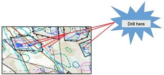
The end result of our search is:
- Detection and localization of resources in the traps
(reservoirs) of potential hydrocarbon deposits, the
international category P3;
- The quantitative estimation of probable hydrocarbon
resources;
- Reasonable ranking of identified objects (traps, tanks) their
perspective;
- Construction of 3-dimensional model of the revealed us the
object (structure, trap, reservoir) with very high
detail;
- Development of recommendations for the formulation of further
exploration and appraisal drilling operations, as on the
continental and on a shelf
A modern technological base and high qualification of our employees, as well as competitive prices enable us to offer our partners the most advantageous conditions of work and treatment of the results of geophysical research, as well as the entire complex «remote exploration », offered by us.